A couple of months ago I lamented about the lack of really good apps that work well in the outdoors, far away from cell coverage.
It has never been about me bringing my online life with me on the trails. I mean, I can live without a few hours of checking my Twitter feed, or can I?
 But the iPhone can be really useful and positions itself as a useful companion, a remote control for life if you will, in many areas of ones life. However, most functions require connection to Wifi or at least LTE. Without decent coverage you’re left with a decent point and shoot camera with crappy battery life. Not just because many apps require coverage to connect to a network, but because it seems app makers spend every hour of their life in their air-conditioned start up office with fiber internet. Not the place to dream up great apps for the outdoors, it seems.
After a recent trip into the wilderness, off trail, I began researching GPS Map apps again and I remembered one of my all time favorite commercials: Apple’s great “Your Verse”, narrated by the late Robin Williams.
Don’t mind me, I just got something in my eye…
In the ad the mountaineers Adrian Ballinger and Emily Harrington used an app with their iPad mapping and pinpointing locations in harshest conditions… like on Everest. So I decided to download a couple apps, and Topo Maps+ stuck with me. Topo Maps+ is one of the apps the couple used in the commercial, and it’s a free download which allows you to test the usability. Topo Maps+ offers In-App purchases to be granted various Maps to get unlocked. $15 unlocks high resolutions maps for a year, which I felt was a no-brainer to spend after test-driving the app for a few minutes.

Image from Glacier Peak Studios
(Warning: Apple’s App Store search is totally crapped out. Searching directly for Topo Maps+ give you tons of results, this is the direct link to the app I’m talking about.)
The app is available for iPhone and iPad and has an Apple Watch companion app as well, which I haven’t had a chance to try out… yet.
A mapping app, like any physical map, has a dual function. It needs to work well outdoors, but it also needs to be able to play an integral part in the planning of your trip.
Topo Map+ is just that, a GPS mapping app. It works similar to the official Apple Maps app, but for the planning phase, it offers the crucial download feature of map tiles. You select the area you’re planning on hiking and download high resolution map tiles.
I can’t stress enough how crucial this step is. Without the high resolution maps, the app will find your GPS location out in the wild, but can’t offer you the map tiles to show you where you actually are.

Image from Glacier Peak Studios
Topo Maps+ offers an array of different map overlays. You can view different terrains, topo maps for running and biking and the default and official USGS Topo.
The app offers various ways to select waypoints on the map and even trace routes before you even head out. This is best done on the iPad and synced to the iPhone.
A helpful in-app manual explains all the various elements for planning of trips, tracing of routes and adding waypoints.
A simple and straightforward share menu allows you to print maps and share map data with friends or with other apps.
TIP: In iOS 8.3, you can use GPS on your iPhone in Airplane Mode, which helps a lot with battery life when you’re out in the wild. Your phone won’t be constantly trying to pinpoint any possible cell towers in range, or not.
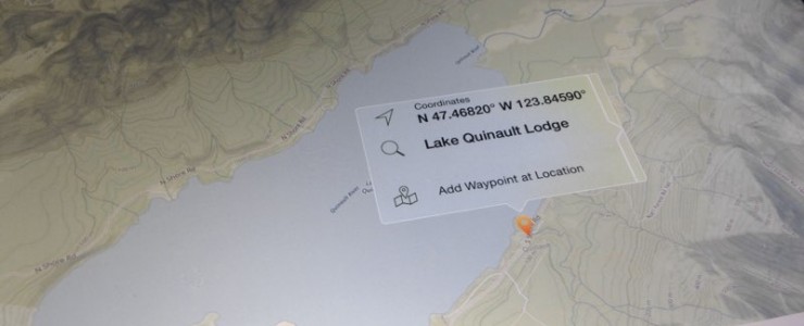
On the trail, the app works straightforward and is obvious- When you launch it, it centers your blue location icon on the map tile. When pressing your location marker, a submenu will pop up with exact coordinates, the level of GPS accuracy, your current elevation, the direction you’re heading, and the speed you’re moving.
That’s all I really need on the trail, but the app offers live tracking, and includes route setting. You can also drop custom pins on the maps for later use.
TIP: Be sure to calibrate your Compass app before using your phone as a directional device.
Glacier Peak Studios is the app developer of Topo Maps+. It’s their only app in the app store, which is a sign how serious they are taking this app and the polish and focus shows this.

At my recent family hike to Pony Bridge, on the popular trail leading to the Enchanted Valley, the GPS was never off by more than 30-50ft.
My kids loved asking what direction we’re heading, how much further it was, and how many more feet of elevation we’d have to climb. The app not only served as a way to make sure we were going the right way, but also proved to be a valuable educational tool, as well.
Overall, I’ve only touched the surface of what the app can do. I’ve not played with the features which allow you to save trails and routes, but this is really not what I want to use the app for. I want a simple and accurate mapping app I can use when I’m out on the trails, especially in the backcountry and Topo Maps+ has earned a place on my homescreen for this purpose. Topo Maps+ is totally worth downloading and you should do it right now. You won’t regret it.

Come race the world!
Beast of Big Creek is North America's only stop on the Skyrunner World Series. Mount Ellinor is waiting for you.
Singletrack is part of Trail Tracks Network.
Singletrack is a owned by Einmaleins and part of trail. run. film. Productions. © 2018 - 2026. All Rights Reserved.