Winter is fast approaching and wilderness loving trail runners are looking for weather approved trails offering miles, elevation and weather accessibility.
As the season transitions into the shorter daylight months, many of the remote trails we ventured to during the summer months are often blocked due to fallen trees or overflowing streams. Higher elevation destinations we powered up are soon going to be covered in that white powder, transforming trail running into adventure running. Unlike the carefree summer running months, winter running requires a lot more planning and foresight. This is not a bad thing at all. I, like many of you, am looking forward to revisiting some of my new favorite winter destinations in lower elevations and braving some snow when it finally gets there. But…

If you need a long run that gets you out the door quickly, without the need of meticulous preparation, here is my challenge for you: go run my route at Tolmie State Park along the South Puget Sound.
South Sound running folks usually find themselves plodding along the trails at Priest Point Park or Capitol Forest, or even LBA park. While those a fine choices, I recently discovered my love for Tolmie State Park and created quite a fun route. While I’ve been running there for a while now, I found a cool loop run, turning sweet little Tolmie State Park into the perfect trail running track Nirvana.
At Tolmie State Park, the trails aren’t very long, so crafty skills are required to make the most of them. The loop I have made it a bit mentally challenging, so having a weird obsession to hilly single track trails is needed to not lose you mind out there. In order to turn the three miles of trails into something awesome, there is only one solution – You’ll need to run lots of loops. I know, loops sound boring and I completely admit it.
But Tolmie makes it worth it, thanks to cool trails, awesome views and the perfect mix of elevation. I’m committed to get you hooked. I even got Doug to admit he enjoys running out there and he hardly says he enjoys running.

To do the loop that I do, you’ll need to be slightly familiar with the trails. The trails are easy to follow, but to perfect my loop, you’ll need to head out there and compare your run with mine on Strava. My main loop is just about 3 miles with about 350 ft. of elevation. I realize that this is not something most of you would get out of bed on a Saturday morning for, but if you string several loops together, you can get some decent mileage in and have an enjoyable time.
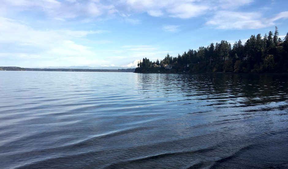
To run this route: Start at the upper parking lot, head down the steps behind the shelter toward the lower parking lot. Run past it and enter the trails at the end of the turnaround spot. Follow the Four Cedar trail which winds its way to the first steep incline. From there follow the main and really only trail as it makes its way up and down through the woods. After about 1.5 miles there’s an intersection with the Twin Creeks Trail, which is a short cut to the lower parking – ignore it. You want to head left, back up the hill where you will soon intersect with another split in the road. Left toward Sandy Point Road will take you out of the park, so stay right until it spits you back out by the main picnic shelter by the beach. There follow the Sandy Beach trail to the far beach, snap a picture of Mt. Rainier if she shows her white face in the distance above the sound, and head back to the picnic shelter. Pass the shelter, cross the bridge onto the beach where you get to enjoy running along the Sound in all it’s glory. Run along the beach to the far trail which takes you back up to the upper parking lot area. Rinse and repeat.
The trail itself is over 90 precent single track, with some beach running and just a bit of pavement on the upper parking lot. The Four Cedar trail is surprisingly hilly, but not insanely challenging. The constant elevation changes keep you on your toes and also provide a great dose of elevation to your legs. Be aware that like most of the trails in the PNW, several boardwalks can be slippery and once the rain really descends upon us you’ll need to navigate several large puddles.

The main things I love about loop running is that you have your own aid station built right in. Think about it, every three miles you’re back at the car. No need to take water, gels, layers of clothing or the ten essentials. Need a bathroom? Right there too. You’re never alone out there. People walk their dogs, you pass families with kids and the occasional other runner. It’s a safe place to run, in any weather.
If you’re not fully prepared for the elements, or have an off-day, you can easily head to Tolmie and get in short run. However, stringing several loops together can easily lead to a run of 10 to 20 miles along the fantastic trails along one of the South Sounds most awesome State Parks. Seriously though, where else can you have this much adventure with built in aid stations, stunning views and perfect single track trails with elevation?
 There are several Strava loops already created, so I’m clearly not the only one running out there. I did, however, just created a new segment which contains the longest possible route I can think of in Tolmie State Park. My current record is five loops. That comes to 15 miles (at least on my GPS device) and 1,750ft. of elevation gain. It took me just under 3 hours, which is nothing to write home about, but it gives you a perspective of how long each loop should take (Just over 35min each.)
Record your run in Strava and send me a link via Twitter.
I’ll keep track of all the best times here on this website.
Can’t wait to see what you come up with.
When the tide is out, running along the water is great, making for a fantastic spot to take a quick breather and enjoy the view. Otherwise, when the tide is in, most of the beach is under water.
During the rainy Fall and Winter the trail can be muddy at places.
You’re not running alone. Watch for other’s on the trail and remember good trail etiquette.

This destination is part of my upcoming book Base Camp Olympia. Shipping this winter 2016. Available for pre-order as eBook and Softcover Collector’s Edition today.


Brooks Running invites you to a very soecial screening of TRFF'26. Scott Jurek will host the evening. Truckee, CA, Jun 25 - get your tickets.
Singletrack is part of Trail Tracks Network.
Singletrack is a owned by Einmaleins and part of trail. run. film. Productions. © 2018 - 2026. All Rights Reserved.