There is a mountain peak on the Olympic Peninsula and it has been staring at me, beckoning me for many years on clear skies from almost every corner of the Puget Sound. That peak is a beautiful mountain with great exposure and it sits right next to one of the most hiked mountains in the Pacific Northwest. That mountain is called Mount Washington. At 6255ft. it’s the couple-hundred-feet-taller bigger sibling of the well-loved Mount Ellinor. Mount Ellinor gets all the hype and traffic, Mount Washington deserves equal, if not more praise.
After several trips up Mt. Ellinor, in Summer and Winter I made it my goal to climb this beautiful mountain, and not just once. I wanted to fully understand and document the most common route to the summit and further explore the traverse to Mount Ellinor. For that I had applied for the American Alpine Club’s ‘Live your Dream’ Grant, but wasn’t chosen, which didn’t affect my desire to grab the next possibly opportunity and attempt to stand on its peak.

On the upper part the trail winds itself along a steep rock face. Just play mountain goat and you’ll be fine.
Mount Ellinor trail descriptions are included in every trail book, outdoor adventure guide, and almost every hipster magazine these days. But trying to find Mount Washington route descriptions was a lot harder, both online or offline.
Why is that, I wonder? The mountains are right next to each other. Both are equally easily accessible and Mount Washington is even higher? Why aren’t there more people on this beautiful mountain, especially considering that people endlessly complain about the recent traffic increase on Mount Ellinor.
Why Doug and I picked Mount Washington this weekend is easy to explain: We love the Staircase region above Lake Cushman by Hoodsport along the Hood Canal. It’s the closest outdoor destination from our home town and basecamp Olympia, Washington. Just a short drive up the Pacific Coast Scenic Byway on 101, head right toward Port Townsend and not towards the beaches. Beaches are for other times.

That valley, that view. We live in a fantastic place.
Hoodsport is busy in the Summer and it was great to see so many people out in the shops and the Visitor Center of the National Park and Forest was buzzing with activity.
We followed the main route towards Lake Cushman and Staircase at the Big Creek campground intersection and headed right towards Mount Ellinor on Forest Road 24.
After about 15min of dirt road, passing the lower trail head to Mount Ellinor we reached the intersection leading to the Mt. Ellinor Upper trail head, don’t turn there, but head straight until the dead end, there’s place to park your car there.
No sign-in sheet, but a big bolder on the left side of the road marks the actual trail head and beginning of the trail. This already was a sign that this trail is far less frequented by hikers than it’s little brother.
Mount Washington is a climb, not a hike and it separates the casual day hikers from the climbers.
Right from the get go the trail is steep, very steep. We gained 3200 ft in just 2 miles and within a few hundred yards, amidst thick forests and great big boulders we encountered the first headwall.

Mathias navigating one of the first headwalls.
The popular trail to Lake of the Angels is widely considered to have a ‘headwall’ on the upper part of the trail. According to this a headwall is a steep section of the trail that might require you to use your hands for balance and ‘scramble’ up the trail. You most likely won’t need a rope, or other climbing gear. But you need to be surefooted, understand the ‘3-points of contact rule’ and be okay to deal with a bit of heights, especially on the way down.
So, yeah, the lower trail of Mount Washington has headwalls.
Headwalls in the thick forest are fun. Tons of roots and big rocks make climbing those enjoyable. I should probably mention that it was a nice dry day. Attempting this trail in wet conditions could make for a possible harrowing experience.
I also spotted several big boulders in the lower section which make me want to bring my rock climbing shoes next time.

Lower valley – first little break from the steep ascent.
After about 45 min we reached the first little valley which offered a bit of a rest for our quads.
We followed the trail which lead through a dry stream bed and reached our first scree field.

Scree fields are necessary evils in mountain climbing and are especially present in the mountains of the Olympics; both due to the porous nature of the rock and the lack of clear defined trails. I thought I could find not an ounce of good about those damn scree fields until our way back down where I realized you can ’board-style’ slide down on some sections. Fun, but don’t sue me if you get hurt. Man, that was fun… I digress.
The first scree field lead us back into a more wooded section where we needed guess the trail in a couple of sections. A couple smaller headwalls later we made it to the Meadow Basin.

Three trails lead though this gorgeous valley. The middle one is the one. In the distance our destination in sight.
Oh, that Meadow Basin. Has no one gave it a better name yet? It was enchanting, … oh, that one is already taken? Well. With the wildflowers blooming and few great looking boulders this small valley made us stop to rest and refuel a bit.

The wildflowers are exploding on the upper Meadow Basin.
The valley has three trails leading through it and we followed the middle trail after a description we found online.
At the end of the valley we ended up at the first serious headwall.

Taking the lead at one of the longest headwalls on the trail.
My breakfast eggs are scrambled, sometimes. My climbs are not.
Scrambling sounds so… childish, so uncontrolled, random, careless even.
We didn’t scramble up this headwall. Yes, it wasn’t a pure climb, we didn’t rope up, and we didn’t measure the difficulty but we surveyed to situation, chose the best path and carefully staked our route. I don’t call this scrambling, I call it mountaineering, even if I didn’t have sherpas with me carrying my gear.
This headwall isn’t very exposed, but the quick elevation gain and need for concentration and communication gets the heart pumping.
Once up the wall you could feel we were getting closer to the summit and were getting excited, but first the second, and bigger, and nastier scree field.
Two steps up, one step down.
It’s just loose rock, sharp, wobbly, rolling rock on an steep section of the, often indistinguishable trail. The small stuff is annoying, but even the bigger rocks are loose, deceiving, and can instantly turn a well-placed step into a questionable decision. Finding a route takes a good read of the terrain and most often a couple detours.
Even the best climbers have lost some of their dignity in a nasty scree field I am told.
At this point we were about 90 minutes into our climb and having successfully crossed the scree field we finally reached the fun part. The trail, narrowing in section to what looks like an animal trail, lead us past a large rock gully, with incredible views and the feeling you’re climbing a mountain.
In Europe this section would probably be secured with a fixed metal rope for extra safety, considered part of a Via Ferrata.

Doug is fooling around, telling me to take picture of his grandeur.
Most descriptions we found online didn’t talk about one of the most exciting places we found on this climb. Some friendly folks before us built a make-shift camp side right on the saddle where we took a break and had lunch.

The saddle – the perfect lunch spot.
Doug and I loved that saddle area so much, I think we took the longest lunch break we’ve ever taken. It was a great place to hang out and explore.
To the left of the camp side is sort of a false summit with a few cool boulders we instantly had to explore and climb. With better weather the views would’ve been spectacular and we could’ve waved to the folks gathering at the summit of Mount Ellinor just to the West of us.

The saddle from the ‘false summit’. The trail to the summit is clearly in view. Our hiker friends are passing us, reaching the summit just ahead of us.
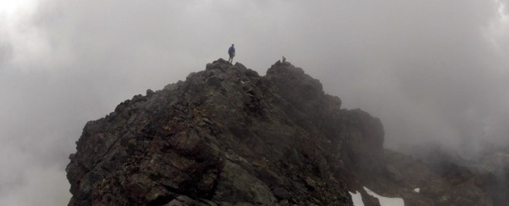
The real summit of Mount Washington lies to the right of the saddle and after chatting for a couple of minutes with the only other two climbers we encountered on the upper section of the trail we packed up and started the final push.

Heading up from the saddle toward the summit.
The last section to the summit takes only about 20-30 minutes. The route is obvious but is by far the most exposed and narrow. In several sections you’ll want to hold on to the rock face and place your feet well. The trail leads you past the summit and around the back. Climb up a few big boulders and walk the ridge-line to your final destination, which is a summit so small only a few people at the time can comfortably rest there. Our friendly climbers we met earlier and had been on the summit waiting for a break in the clouds graciously made way for us as we approached.

On the trail just below the summit. It’s getting interesting.
The summit of Mount Washington actually had an awesome rusty summit box with personal notes inside from delighted and exhausted climbers.
The modern tech idiots we are, we had nothing with us. Not a pen, not a piece of paper, no business card, nothing. There’s no app for that, I guess.

The summit box we left behind without being able to add any memory of ourselves. Dammit, we must go back.

Doug at the summit.
We took several pictures on the summit but the clouds started pulling in and visibility became an issue. So after about 3.5 hrs, including our long breaks we started our trip back down one of the most awesomest mountains I have ever climbed (including the mountains I climbed in the Alps – yeah, that great!)
The exposed upper section feels different when you’re facing downwards, you need a bit more concentration. The scree fields are actually sort of fun as I mentioned above and the headwalls sometimes require you to use your fifth contact point on the ground – slide on your a** for fastest descend.

Doug at one of the final headwalls at the lower section of the Mount Washington trail.
Often on our hikes I like to run the last couple of miles back to the trail head. My legs feel bored with the slow trekking downwards and I want to let it all out and run. Feels easier, I tell myself. But not this time. This trail is from top to bottom way too steep to even get into a slow jog at any stretch of the route.
But this also meant that I wasn’t completely drained when we reached the car.
The trail has pretty brutal elevation gain, but it’s just a 4.5 miles roundtrip to the summit and back so I still had some energy left in me and didn’t long for Pringles and Gatorade to refill my depleted energy level, like I usually do on longer hikes.
So, one hundred percent, this mountain fulfilled all my hopes and wishes. All my penned up excitement was met. This wasn’t just a hike to a little dingy lake on endless forest trails, like so many suggested and well loved hikes around the area. This was climbing a real mountain, and I just did it. And as a bonus the mountain is super-close to my home so I definitely will be back soon during better weather to attempt the traverse to Mount Ellinor. That will be the ultimate trophy in my collection for this year.

Often we stop at this viewpoint along Lake Cushman looking anxiously at Mount Washington after or before climbing Mount Ellinor. Not anymore. This one’s in the bag!
Right after the Mount Washington trail head the forest road is washed out for car travel . But you can walk/hike down, continuing along the road and around the bend toward a fork of Big Creek. There you’ll find a very cool little waterfall and fantastic views of Mount Rainier far in the distance. The rocks around that area look very climbable and we found a couple areas that could work as campsites. There must be people with similar ideas. This area deserves more exploring and is totally worth a little detour when heading back from Mount Ellinor next time up there.


Come race the world!
Beast of Big Creek is North America's only stop on the Skyrunner World Series. Mount Ellinor is waiting for you.
Singletrack is part of Trail Tracks Network.
Singletrack is a owned by Einmaleins and part of trail. run. film. Productions. © 2018 - 2026. All Rights Reserved.