Toward the end of Spring, Doug and I explored one of Mt Rainier National Park’s many forgotten corners, the Westside Road. We hiked up to the Mt. Tahoma Suspension Bridge and from there, trekked along a portion of the Wonderland Trail to Emerald Ridge and back along the Puyallup River and Round Pass. In whole, it was just shy of a 20 mile day in balmy pre-Summer heat with glorious and surprising views of the mountain.
Before you read on a word of caution taken directly from the NPS website:
Winter damage to Westside Road – Challenging for Hikers; Impassable for Bicyclists: Westside Road is now open from the junction of Nisqually Road to Dry Creek. The road suffered major damage between Dry Creek, the end of the maintained road, and the former Tahoma Creek Trailhead. Last fall heavy rains caused Tahoma Creek to flood and wash out the old road bed, which has been used for foot and bicycle traffic. The washout is such that it is a challenge to hike around due to steep banks and stream flow. Bicycle traffic through this area is impossible and would require carrying a bike around the washout, which would be extremely difficult. At this time there is no maintained route around the washout. Conditions beyond the washout are unknown, but it is likely the road is blocked with trees down and possibly more washouts.
My new hiking boots I had mentioned on one of our Adventure Dispatches a few weeks ago were beckoning me to take them out, and with a forecast of temperatures in the 90’s, I gladly obliged.

Doug and I have been on many adventures together over the last few years. We ran trails in the snow and rain, we hiked to lakes and stood on peaks. But for some reason, whenever we’ve planned something in the past, we end up hitting 101 and exploring the Olympics Peninsula and Olympic National Park. Not once had we been together at Mt. Rainier National Park.
By ourselves, we both have been to the park countless times. The close proximity to our hometown of Olympia and the legendary destinations at Sunrise and Paradise make the park a great family destination.
This time, Doug and I really did leave early, something that Doug struggles with. Despite his insistence he isn’t a morning person, Doug picked me up just after 6am. We hit the Ashford/Longmire park entrance just before 8am and were one of the first people in the park. As we gathered our gear at the Westside Road trailhead, it was already pretty warm and with the forecast of 90 degrees we took extra water for our trip. This was to be the hottest day of the year and we wanted to be prepared.

The trail first led us along the overgrown forest road. We hiked in beautiful scenery as small waterfalls tumbled down from the cliffs overhead and small peak-a-boo views of Mt. Rainier greeted us in the distance.

After about 1 mile we reached the makeshift trail head leading into the forest toward the river. Weaving in and out of the large dry riverbed filled with boulders, we followed the trail upstream avoiding a few washouts and several blowdowns. This requires some navigational and route finding skills. Our first goal was to reach the Tahoma Creek Suspension Bridge and Doug promised me an unforgettable experience with breathtaking views. Once our trail connected to the Wonderland trail it was just another couple of minutes until we hit the bridge.

In Doug’s words from a couple years ago:
“One hundred and sixty five feet above Tahoma Creek, the suspension bridge swings for two hundred feet, supported only by cables and a wooden walkway with quarter inch gaps between each board. To say that this is a tough bridge to cross depends on how you deal with heights. For many, they will look at the bridge, shake their head no while cursing a few words and head back to the car. For a few of us, it is yet another bridge in life that has to be crossed, but this one happens to be much more scenic that others. For others, the bridge becomes a personal challenge, something to overcome, representing a struggle in their life they are dealing with. For those, each step on the bridge is an adventure, feeling every wobble of the cables and hearing every creek of the bridge as it sways in the wind.”

Yeah, this bridge is indeed incredibly awesome. Check the pictures and check your heart rate. It’s totally worth a visit, even if the trek to get there is tough (or long if you come from the other side of the Wonderland Trail via Indian’s Henry Hunting Ground.

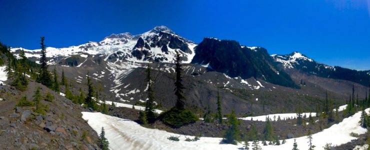
After taking way too many pictures, we continued along the Wonderland Trail towards Emerald Ridge. The trail wound it’s way up, gaining in elevation, soon becoming snow covered in some areas. Once beyond the tree line, we used to our trusty mapping app Topo Maps to help us stay on the trail while we navigated the large snow fields at 5,700 ft.

The views from this side of the park were absolutely stunning: Tahoma Glacier in front of us, waterfalls all around us feeding the Tahoma Creek and Puyallup River and Mt. Rainier in all her glory. This is a perspective I had never seen before, as majestic views covered the entire panorama expanding out in front of us. We took more time here taking pictures and just staring in bewilderment at the beauty of Mount Rainier.

Once we finally felt we could peel ourselves away from the views, we continued along the trail. As a point of interest to make this trail a loop, the Wonderland Trail crosses Emerald Ridge and from there you can do what we did and head back down along with the Puyallup River, which for us was now gurgling away thanks to the heat and melting snowpack.

We gained speed heading downhill and soon connected to the Puyallup River trail where we left the Wonderland Trail behind.

Reaching North Puyallup Camp and Devil’s Pipe Organ, which was a breathtaking sight, the trail started to show signs of winter storms and long overdue trail maintenance.

We encountered a washout on a very steep section of the trail that was fairly tough to navigate and posed an obstacle certainly not for casual hikers. We also encountered lots of lots of fallen trees, which in spots had completely covered the trail ifor hundreds of yards, making progress a difficult beast.

Once we had the worst behind us, we cut the trail short by hiking over Round Pass, which connected us back to the gravel road.
When we met the road, it was about 2pm and over 90 degrees. The sun beat down on the exposed gravel road and all we had left were the final 4 miles back down to the trail head.
After a much needed beer at Whitaker’s Rainier Basecamp in Ashland, which helped us cool off, we headed home.

There is a lot of off-trail hiking on this route. You have to be comfortable reading a map and route finding. You will be navigating boulder fields and need to find safe ways to travel around precarious washouts and through many fallen trees. You will also need to bring plenty of gear, water and food. This is a long hike.
It’s perfect for early season adventures. The Westside Road is close to the Ashford/Longmire entrance, so it’s easy to get to the trail head. Away from the crowded visitor centers, this area feels almost forgotten and in many ways is. The views are unique and breathtaking and we would do this again in a heartbeat.

The Skyrunner World Series is back in the USA!
Join us at Beast of Big Creek and race Mount Ellinor with us.
Singletrack is a owned by Einmaleins and part of trail. run. film. Productions. © 2018 - 2026. All Rights Reserved.