I do not love being in the wilderness by myself. I really don’t. It’s not blind fear or a phobia. It’s being in my head; all by myself for hours, not being able to share the experience with anyone that sort of lacks any draw for me. I guess, I don’t like loneliness. Doesn’t make me a good Northwest outdoor person, I suppose. Most people go outdoors to get away from everything and anyone. Not me.
But, just before the weather turned this fall, I wanted to test myself, wanted to try out that solo experience and see what it was all about.
After my big trail race in late August my legs were exploding with energy and I felt there was another big trail run in me before the peaks would see their first snow. I wanted something long and far, yet familiar.

Mount Gladys, above Glady’s Divide past Flapjack Lakes out of Staircase in the Olympic National Park, is no unknown territory for me, but I’ve never been out in the wilderness solo. From the Staircase trailhead, Mt. Gladys is a 25mile round trip – which makes a long day if you want to hike it and most people reach Gladys Divide after camping at Flapjack Lakes. One makes their way along the North Fork of the Skokomish River to the junction up toward Flapjack Lakes. From there the trail turns steeper as you climb up towards the lakes, crossing Madeleine Creek, past Donahue Creek Falls and the junction toward Black and White Lakes. From Flapjack Lakes, it’s another couple of miles to the Divide and another 3/4mile to the summit. Average hikers make the trip in about 12 hrs. I ran it in just over 5 1/2hrs.
I love going out with other people, love the company, the conversation, laughter and the collective achievement. I much prefer it to solo trip. But as schedules permitted, I had to make the choice of not going at all, or attempting my first solo trip. I didn’t take this lightly, this required a lot of mental convincing.
I left the house early, was the first at Starbucks on the way out of town and made it to the trail head in record time. At the ranger station I took a deep breathe and gathered my gear. This would be a long day just being in my head and I needed to be okay with this. I made sure I absolutely had all the gear I needed and double and triple-checked everything. There was no need to rush, I was one of the first ones on the trail and met only a handful of people all day.
I was familiar with the route and knew what I would be expecting, so I begun my run in a leisurely pace, taking the North Fork Skokomish trail toward the junction up to Flapjack Lakes.

When venturing with friends, trail junctions usually offer moments to break, breathe, rest. Running alone I felt weird lingering for no reason, so I pressed on. From there, the trail got steeper as I was leaving the gurgling river behind me. Although not highly frequented, the trail up to Flapjack Lakes was in great shape in the early fall. I crossed the bridge over Madeline Creek after just over an hour into the run and knew I was making good time. I slowed my pace and tried to enjoy the scenery and quiet as I was passing Donahue Creek Falls. That wasn’t really working. The discomfort of being out there all alone with no one to talk to never quite left me.
This didn’t surprise me and I knew it would be more of a run against my own clock than an adventure to experience the solitude. Just before reaching Flapjack Lakes, I ran into a couple hikers and we exchanged a few words and hiked with them the last couple hundred feet to the campsites along the lake. By now, I had slowed my pace and I was starting to feel cold. I wished them goodbye and continued on my way.
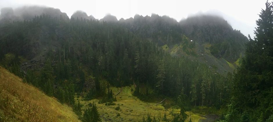
Now, at a faster pace, I followed the narrow trail leaving the thick forest behind me to reach Gladys Divide. The Sawtooth Ridge and Mt. Pershing were covered in thick layers of clouds and it felt eerily quiet as I reached the Divide in just over 2.5 hrs. There, I snapped a few pictures and took a longer break. I plopped down on a large boulder, refueled, put on a dry shirt and evaluated my options. The sun was trying to break through the clouds and I was hoping I would get to see some peaks. Should I push on and make it up to Mt. Gladys? From the Divide it’s not an obvious or well-marked route. A few placed cairns lead the way across the high alpine plains as the clear defined trails disappear. I had my iPhone loaded with my favorite mapping app, TopoMaps+, with me and I had done the route before so I knew where to go even though the clouds cut visibility down to not more than a hundred feet.
My inner ambition told me to go for the peak since that was the goal I had set out for myself. Anything less I would’ve considered compromise.

If you’re hustling, it’s only another twenty fast minutes from the Divide at 5000ft. to the peak of Mt. Gladys at 5589ft. It’s not a prominent summit, but I always love standing on top of it wondering how many people actually make it up there each year. It’s a peak that’s doesn’t require mountaineering skills, there’s no climbing required. But at over 12miles from the trail head, it makes for a very long day if you consider hiking it in one go. Most people visit the Divide while camping at Flapjack Lakes, but if you know me and my love for wilderness camping along bug infested lakes, then you’d know that this is not really an option for me.

At the summit, I snapped a couple of exhausted selfies and without lingering long, I made my way back down again. Passing the Divide, I picked up the pace, realizing bittersweetly that the sun was now starting to win it’s fight against the clouds. As I was entering the forest around Flapjack Lakes, I was starting to run in the bright sunshine. Fantastic. I didn’t have any energy to go back up just for some pictures. Although I was tempted.

Mountain running, which includes a summit as the main destination, usually offers a pretty simple elevation profile. First half of the day is just up, up, up. The crowning achievement is the summit and from there it’s just downhill. Once I reached the Flapjack Lakes Junction I started to feel pretty depleted, I knew the trail ahead was pretty simple but those 4 miles back to the car were quite a grind. I opted to cross the Staircase Rapids bridge to mix things up for the final mile. Once I reached the car at the now bustling Staircase Ranger Station, surrounded by families taking a stroll along the river, I tried to put this entire experience into perspective. But I sort of couldn’t. And I still sort of can’t.
I got some numbers. I know how far I went, how long it took me, and how many feet of elevation I climbed. I didn’t go there for the pictures, the cloud cover prohibited any stellar shots for Instagram.
Did I go to prove myself?
Did I learn anything valuable about myself or the world?
Is there a profound lesson in there somewhere?

Months later, as I am writing these words, I still don’t have an answer, really.
Yes, I loved it, but not in this intoxicating kind of way.
More in the intensely independent sort of way.
I did this.
All alone.


Tailwind's Blueberry Lemonade is back, just in time for summer and only for a limited time.
Get yours and save with code SINGLETRACK15.
Singletrack is a owned by Einmaleins and part of trail. run. film. Productions. © 2018 - 2026. All Rights Reserved.